March 26, 2012

Roadtrip Report: NY Route 12 Utica to Watertown

So today I decided to drive old NY Route 12. I tried to follow the path of Route 12 between Utica and Watertown before it was upgraded sometime in the mid 20th century. I think I was pretty successful at my attempt.

Oneida County makes following old Route 12 fairly easy by labeling it with a county route number that is “out of range”, as the county routes in Oneida are numbered sequentially by location and since old 12 was numbered after the rest, it’s number sticks out a bit. I started out on County Route 91 and followed it north. I passed by an old-drive in theatre, a couple of 40s style gas stations that have been abandoned and several old motels and motor lodges that are still open but have mostly been converted to low rent apartments. Signs of the driving age of the 50s when this was the main route between Watertown and Utica.

Heading north but just south of the hamlet of South Trenton, old 12 used to open up to a four-lane highway with at-grade intersections. This section was converted to a two lane country road a few years ago, making for an extra wide right-of-way that affords the folks that live on the road bigger lawns.


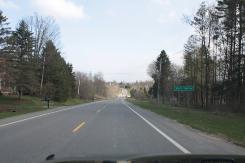
Existing Route 12 maintains the four lane expressway configuration north of Putnam Rd. and I have to jump onto the freeway at that interchange with the Route 12 freeway to get to it, as old Route 12 now makes a 90 degree turn onto Powell Rd (or you will run into a big pile of dirt separating old Route 12 from current Route 12).

I followed existing 12 through the Mapledale Business District and from what I can tell, this is the original roadway that was just widened. From there, Route 12 followed Mappa Avenue into the Village of Barneveld. Quick aside, until 1975, the village’s popular name was “Barneveld” but it’s legal name was “Trenton”. The village’s name has roots in Oldenbarneveld but was incorporated as the “Village of Trenton”. Residents didn’t like that, though, because Trenton, N.J. mail and freight was always getting delivered to Trenton, N.Y. by mistake so that’s why they changed the name. The post office was called Barneveld but the village was called Trenton until the legal change in 1975.

Whew.

Back to old 12. This part took a little exploring today. Old 12 followed Mappa Ave. onto what is now Route 365, where old 12 then followed up what is now the off ramp from now-12 SB to Route 365. From there it crossed over existing 12 and went along the railroad tracks to what is now Plank Rd. From there it veered to the west of the railroad tracks onto what is now an old roadbed that was not suitable for driving but quite comfortable for geese, as there were a ton of them hanging out on there today. Old 12 continued along this old path onto Main Street in the Village of Remsen. In Remsen today I found an old Super Duper grocery store. There used to be a ton of them in these parts, but now they’re mostly gone, including this one.


My Grandma Country once told a story about talking with a woman down south and mentioning that “Piggly Wiggly” was a funny name for a store. The southern woman retorted that it wasn’t any odder sounding than “Super Duper”. I don’t know what happened after that, that’s where the story always stopped.

Old 12 is easy to follow through Remsen and north, because it’s marked “Old State Route 12” though it’s also County Route 82.

Old 12 and current 12 meet up a few miles north of the Steuben and Remsen Town Lines where evidence of old 12’s former routing can be seen along current 12. Old houses are a little off-alignment with the current road due to the removal of curves, trees still form the former front boundary of lawns and there’s a ditch here and there. This motif continues through the hamlet of Alder Creek, where Route 28 leaves Route 12 to head off into the Adirondacks.

This type of routing of 12 continues up to Boonville. I couldn’t quite figure out how 12 used to get through Boonville. The alignment looks like it used to go into Boonville and meander around the village center before heading out, but I couldn’t figure out where it came back out of the village. I picked old 12 back up after crossing into Lewis County, just south of the Village of Port Leyden. Here old 12 parallels current 12 as Canal Street and then Mechanic Street and Kelpytown Rd. until the Village of Lyons Falls, where it meanders through the village and ends up on Cherry St., before joining up with it’s current counterpart. North of here, remnants of old 12 can be seen from current 12 (old bridge structures, abandoned road beds) and it continues like that through Lowville and up to Watertown.

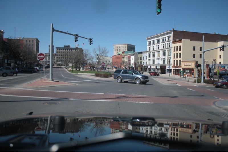
Speaking of Watertown, the city’s downtown has a pretty impressive “square” that still seems to be somewhat busy. There have been many efforts to make it easier to navigate. As a young driver at 16, it used to make me nervous.

From there I let Route 12 do it’s own thing up into the Thousand Islands area, as I did some shopping in Watertown and some other exploring before heading home.

I can imagine that in the mid 20th century when the interstate system was being built and the United States was becoming the land of automobiles, where “happy motoring!” was commonplace, that folks were excited about the straightening of these old country roads. Shoulders were widened and more direct routes were built from point A to point B. As a kid I used to get excited about construction, heck as an adult I still do. (I went and checked out the construction on Future Interstate 781 near Fort Drum today). But there’s a good part of me that enjoys finding the roads that once carried the bulk of the traffic; the predecessors to the high speed roads we enjoy today.

The drive was a good exercise in road geekdom today. I look forward to doing the same someday along the old famous Route 66. In the meantime, I’ll continue to explore upstate New York.

– Proudly posted using BlogPress from my first generation iPad

Roadtrip Stop: Maple Ridge Wind Farm.

So as I mentioned in an earlier blog post today, I went on a road trip like I sometimes do when I have a weekday off from work. Along my travels I passed by the Maple Ridge Wind Farm, which is located near Lowville, New York along NY Routes 12 and 177.

Here is a shot of the wind farm from Route 12 as you’re headed north about three miles outside of Lowville.


And here’s a shot looking towards the tiny hamlet of West Lowville, which is actually four corners where Routes 12 and 177 and one other road meet. The road that is headed up the hill is Route 177, which is one of my favorite roads to drive. You can click the photo to embiggen.


I decided to drive up Route 177 a little bit to see if I could get relatively close to one of the turbines. It was a windy day and I wanted to hear just how loud these turbines were. I have heard reports of people saying that they’re so loud that they can’t sleep. I’ve also heard reports of women having five periods in one month because of the turbine, but I think that’s just a symptom of being cantankerous. As I got to the top of the hill shown in the previous photo, I reached the Eagle Factory Rd. and noticed a little gazebo and trash can sitting in a field alongside the side road. Curious, I decided to go to it to see if it was some sort of information booth.

It was!

Fenced off on three sides so you can’t get to the turbines that are close by (at least without a Six Million Dollar jump), the gazebo has two little display panels explaining that the Maple Ridge Wind Farm generates enough electricity to power about 64,000 homes.


Maple Ridge Wind Farm didn’t have to put up a lot of powerlines; the turbines are connected together via underground cables that come to a common line that runs through the farm. That line then jumps onto a bigger line that runs about a dozen miles to a nearby line, which happens to be one of the highest voltage lines in the United States. Maple Ridge ties into that line, which runs from the Mohawk Valley (where most of the Upstate New York power is switched) to HydroQuébec near Montréal.


Looking northeast off of Maple Ridge Farm. The line near the row is the line that connects the turbines together.


The turbine marked “235” nearest the information center.

I recorded the video you see in the previous blog entry, took the photos and then continued on my roadtrip.

I can understand folks thinking that these wind farms may be intrusive on their land and their scenic view. Sitting atop the Tug Hill Plateau does afford one a beautiful view. And I don’t really believe that wind power is the ultimate solution to the energy needs of the United States, but I do believe that a combination of all the technology available to us (now and in the future) will build us the brightest future as technology progresses and we move towards cleaner energy and away from the older stuff that could be doing damage to the environment.

I have relatives that live not too far from where I stopped today. I’ve seen pictures of family gatherings up there and I have to admit that I found it a little startling to see these turbines in the background, however, I do believe that today’s technology allows us to do everything we can to make these turbines as nonintrusive as possible; they’re relatively quiet, they don’t add to pollution and these guys seem to be located away from areas where birds would seem to migrate (lakes and woods and such). Would I want to live near one of these? I probably wouldn’t protest the building of these if they wanted to put one in the field behind our house. I would see it as a reminder of American progress and our attempts to secure our energy future.

– Proudly posted using BlogPress from my first generation iPad

Video from Maple Ridge Wind Farm.

I tried to capture the sound of the turbines but I wasn’t successful. They’re not loud at all. They make a wispy sound every time one of the blades comes by but they’re surprisingly quiet.

Here is someone else’s video that captures the sound I heard perfectly.

I’m also off on the number of turbines. It’s actually around 140.

Easy.

So today I am off from work because I worked over the weekend, per my once-a-quarter responsibilities of on-call at work. I have to admit that I prefer this way to enjoy a Monday instead of getting back into the weekly work routine, but I don’t know that I enjoy working over the weekend to achieve this type of Monday. Nevertheless, I will enjoy it for what it is. The next time I’m on the on-call is in mid June. I can’t complain about that!

I am currently in the northern New York village of Lowville, sitting in a Wal-mart parking lot eating a Subway sandwich. I’m taking a break from my little project of the day. I am attempting to drive what used to be NY Route 12 before it was upgraded to a more prominent road in the mid 20th century (I think some time in the early 1960s, but I’m not certain on that). There are a couple of reasons that I am doing this but the primary force behind this is that I’m just a geek, especially when it comes to roads. I’ll be writing a separate blog entry about my findings of the original Route 12 once I get my facts straight and am able to look at some satellite imagery to confirm my findings today. So far I have driven through a couple of villages (Port Leyden, Lyons Falls) that I had never been to before, even though they’re less than an hour away from our home. They’re small and what I would call “industrial quaint”.

I have always enjoyed two others villages along Route 12, the Village of Boonville in Oneida County and the Village of Lowville in Lewis County. Boonville is home of the Oneida County Fair each year and still has a quaint business area that appears to still be doing well. I have family that lives near Lowville, which is a cool little village supported by the agricultural goings-on around it. I enjoy the rural charm of this area; there’s no freeway exit leading to the village because there’s no freeway within 30 miles of this place. Lowville is home to the largest wind farm in New York State, Maple Ridge Wind Farm. That’s the wind farm that my favorite road to drive in the summer, NY Route 177, passes through. Lowville is also home to one of a half dozen men I call mustache heroes, a well liked veterinarian named Dr. Peter Ostrum. I saw his picture on television once and his mustache made an impression on me. Google his name to find out why he’s the “most famous man in Lowville”.

Tomorrow my schedule is back on track and your Tuesday is my Tuesday. In the meantime, I’ll enjoy my Sunday, which is your Monday, with a nice Sunday drive.